 Historic Marker
Survey · January 25, 2026
Story of the Slide
As documented January 25, 2026.
- Survey date
- January 25, 2026
- Condition
- Good
- Condition notes
- Panel intact and fully legible; no cracking, fading or graffiti visible. Diagonal sun glare crosses the panel face. The photo credit printed in white at the lower left of the upper-right photograph is low-contrast against the driftwood behind it.
Inscription
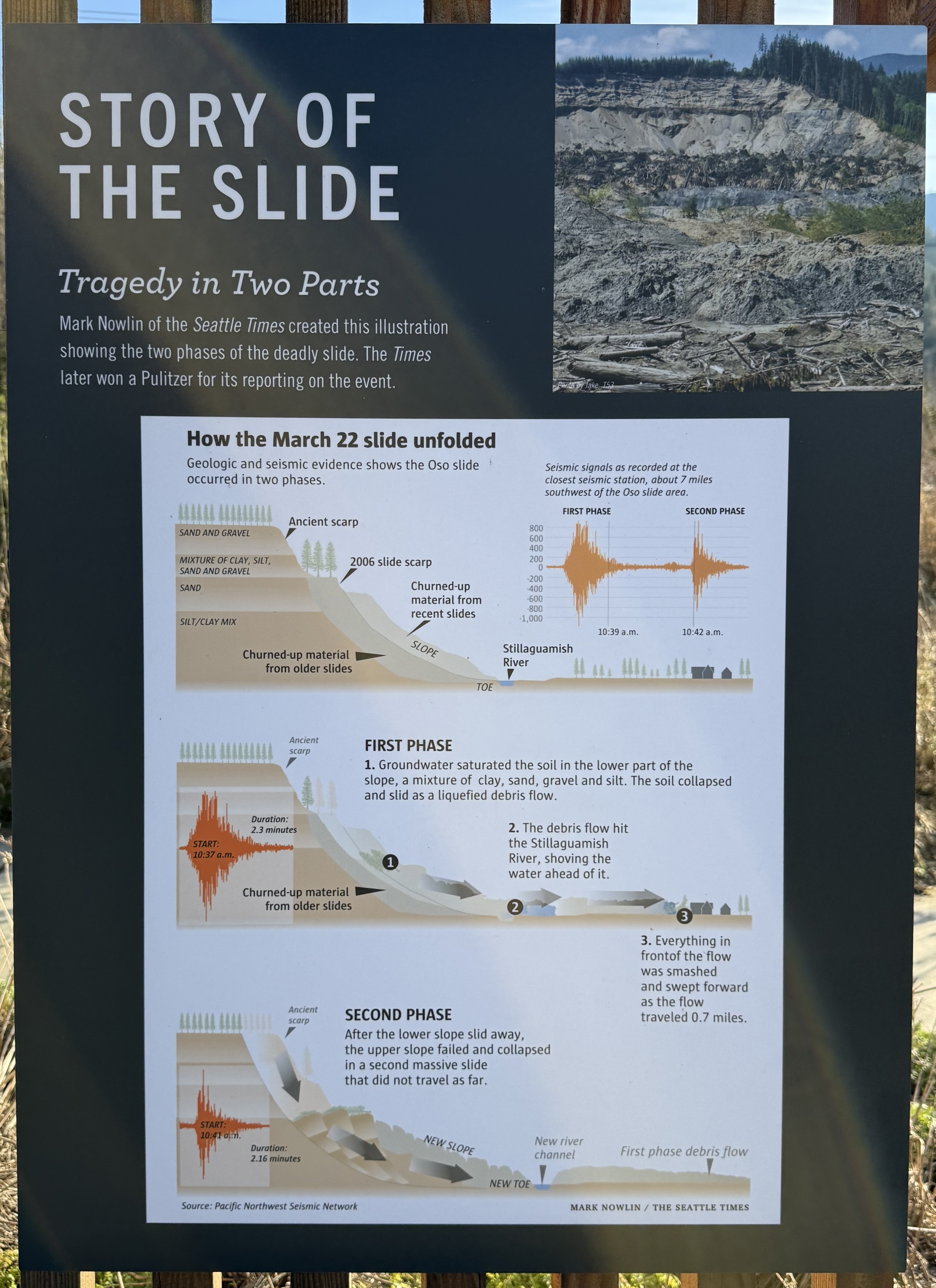
STORY OF THE SLIDE Tragedy in Two Parts Mark Nowlin of the Seattle Times created this illustration showing the two phases of the deadly slide. The Times later won a Pulitzer for its reporting on the event. [Photograph, upper right: bare grey slide scarp above mounded debris and downed logs, forested ridge behind. Credit in white at its lower left:] Photo by Jake_T53 How the March 22 slide unfolded Geologic and seismic evidence shows the Oso slide occurred in two phases. [Seismic trace chart, upper right of the illustration:] Seismic signals as recorded at the closest seismic station, about 7 miles southwest of the Oso slide area. FIRST PHASE SECOND PHASE 800 600 400 200 0 -200 -400 -600 -800 -1,000 10:39 a.m. 10:42 a.m. [First of three cross-section drawings; left-hand strata labels, then callouts:] SAND AND GRAVEL MIXTURE OF CLAY, SILT, SAND AND GRAVEL SAND SILT/CLAY MIX Ancient scarp 2006 slide scarp Churned-up material from recent slides SLOPE Churned-up material from older slides TOE Stillaguamish River [Second cross-section drawing:] ① ② ③ Ancient scarp FIRST PHASE 1. Groundwater saturated the soil in the lower part of the slope, a mixture of clay, sand, gravel and silt. The soil collapsed and slid as a liquefied debris flow. Duration: 2.3 minutes START: 10:37 a.m. Churned-up material from older slides 2. The debris flow hit the Stillaguamish River, shoving the water ahead of it. 3. Everything in frontof [sic] the flow was smashed and swept forward as the flow traveled 0.7 miles. [Third cross-section drawing:] Ancient scarp SECOND PHASE After the lower slope slid away, the upper slope failed and collapsed in a second massive slide that did not travel as far. START: 10:41 a.m. Duration: 2.16 minutes NEW SLOPE New river channel First phase debris flow NEW TOE Source: Pacific Northwest Seismic Network MARK NOWLIN / THE SEATTLE TIMES
Awaiting verification